Ruby Hall
Location: မိုးကုတ်မြို့နယ်
GPS coordinates: 22.89698,96.41826
Latest update: November 12, 2025 19:11

Singu Plateau
52.1 km
Aungge Rapids
47.7 km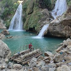
လိပ်ကျ ရေတံခွန်
40.8 km
Seingone
22.1 km
Aung Badarn
17.2 km
ရပ်တော်မူဘုရား
45.2 km
ရှုခင်းသာ
12.8 km
View point
12.7 km
အာဇာနည်ကျောက်တိုင်(၁၉၄၇)ခုနှစ်
9.2 km
Bernard War Cemetery
13.1 km
Thabeikkyin
45.6 km
မဟာမုနိ
10.1 km
Kyauk Hlebein
25.2 km
Sein Inn
16.7 km
View point
3.5 km
Oandan
17.8 km
ေရႊမိကြမ္းယာ shwe mi beatle
221 m
လွတ်လပ်ရေးကျောက်တိုင်
35.3 km
မိုးမိတ်ဟော်နန်းပရဝုဏ်
34.9 km
ဘန့်ဘွေးကျင်းရေတံခွန်
54.6 km
Bant Bwe Gyinn Waterfall
54.6 km
Waterfall
54.1 km
Waterfall
54.2 km
Waterfall
54.2 km
Waterfall
54.2 km
Waterfall
54.2 km
Waterfall
54.2 km
Waterfall
54.2 kmReviews
Visited this place? Tap the stars to rate it and share your experience / photos with the community! Try now! You can cancel it anytime.
Discover hidden gems everywhere you go!
From secret cafés to breathtaking viewpoints, skip the crowded tourist spots and find places that match your style. Our app makes it easy with voice search, smart filtering, route optimization, and insider tips from travelers worldwide. Download now for the complete mobile experience.

A unique approach to discovering new places❞
— Le Figaro
All the places worth exploring❞
— France Info
A tailor-made excursion in just a few clicks❞
— 20 Minutes