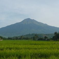
Mayon Peak
Location: Negros Oriental
GPS coordinates: 10.37327,123.28023
Latest update: November 14, 2025 20:46
Kanlaon Volcano
16.7 km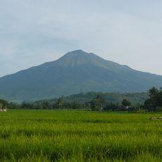
Parco naturale del monte Kanla-on
16.8 km
ROCK
14.1 km
Guadalupe Reef
13.4 km
San Antonio Reef
15.3 km
Quipot Falls
9.5 km
Gigalaman Waterfall
11.6 km
Cherry Blossom Trees
15.2 km
Punod Viewing Deck
17.4 km
Canlaon Century Tree
8.3 km
Hardin sang Balo
17.7 km
La Playa De Valle
6.7 km
Peeble Beach
7.5 km
Malantan-og Viewdeck
15.9 km
Overlooking Old Crater
16.8 km
Negros Chocolate Hills Viewing Point
15.6 km
Overlooking Sipaway Is.
17 km
Mayon Peak
292 m
Chocolate Hills Viewing Point
16 km
Punod View Deck
17.3 km
Scenic viewpoint
16.2 km
Overflow Bridge and Hanging Bridge
18.4 km
Negros Chocolate Hills
8.8 km
Scenic viewpoint
15.4 km
Mount Kanlaon and valley
17 km
Scenic viewpoint
18.3 km
Kinayan falls
18.5 km
Padudusan Falls & Natural Water Slide
12.2 kmReviews
Visited this place? Tap the stars to rate it and share your experience / photos with the community! Try now! You can cancel it anytime.
Discover hidden gems everywhere you go!
From secret cafés to breathtaking viewpoints, skip the crowded tourist spots and find places that match your style. Our app makes it easy with voice search, smart filtering, route optimization, and insider tips from travelers worldwide. Download now for the complete mobile experience.

A unique approach to discovering new places❞
— Le Figaro
All the places worth exploring❞
— France Info
A tailor-made excursion in just a few clicks❞
— 20 Minutes