Сырные пещеры
Location: Каменномостское сельское поселение
GPS coordinates: 43.77401,41.97903
Latest update: November 18, 2025 17:51
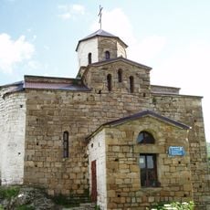
Shoana Church
8 km
Каменномостская боевая башня (Каменномост)
5.9 km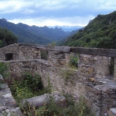
Ruins of Skete of Holy Mount Athos monastery, Karachayevsky District
8 km
Городской фонтан
5.4 km
Memorial to the Victims of Political Repression
5.5 km
Заезд на Шоанинский храм
7.5 km
Сырные скалы
16 m
Мозаичная остановка
3.5 km
Кубанская теснина
6.1 km
Вид на Эльбрус
11 km
Шоанинский Храм
7.9 km
Scenic viewpoint
9.4 km
Мамонтовский размах
8 km
Обзор Карачаевска и долины р. Кубань
5.6 km
Scenic viewpoint
873 m
Аул Мара основан в 1303 году
7.6 km
Аланский Некрополь 8 век
7 km
Столб 1862года
4.5 km
Памятник ВОВ
6.6 km
В.И. Ленин
8.5 km
Святой Уастырджи
7.5 km
Горянка
5.5 km
Monument
8 km
Водопад Мара
865 m
Мамонтовский водопад
861 m
Шушан
8.4 km
Waterfall
8.1 km
Waterfall
8.2 kmReviews
Visited this place? Tap the stars to rate it and share your experience / photos with the community! Try now! You can cancel it anytime.
Discover hidden gems everywhere you go!
From secret cafés to breathtaking viewpoints, skip the crowded tourist spots and find places that match your style. Our app makes it easy with voice search, smart filtering, route optimization, and insider tips from travelers worldwide. Download now for the complete mobile experience.

A unique approach to discovering new places❞
— Le Figaro
All the places worth exploring❞
— France Info
A tailor-made excursion in just a few clicks❞
— 20 Minutes