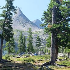
Каменный город
Location: Танзыбейский сельсовет
GPS coordinates: 52.86458,92.98628
Latest update: November 5, 2025 07:00
Ergaki
24.7 km
Oyskoe Lake
17.6 km
Висячий камень
24.9 km
Ergaki
26.9 km
Каменная арка
25.3 km
Камень-покатун
25.6 km
Грот
27 km
Scenic viewpoint
28 km
Scenic viewpoint
18.2 km
Scenic viewpoint
19 km
Scenic viewpoint
18.5 km
Scenic viewpoint
27.9 km
Вид на Грацию
26.8 km
Scenic viewpoint
28 km
Балкон над пропастью
25.5 km
Memorial, commemorative plaque
25.6 km
Оваа
18.5 km
Место гибели Генерала Лебедя
18.3 km
Жемчужина Саян
23.8 km
Waterfall
27.7 km
Waterfall
27.6 km
Богатырь
27.4 km
Грация
26.7 km
Waterfall
27.6 km
Waterfall
27.6 km
Waterfall
27.6 km
Waterfall
27.4 km
Тушканчик
26.9 kmReviews
Visited this place? Tap the stars to rate it and share your experience / photos with the community! Try now! You can cancel it anytime.
Discover hidden gems everywhere you go!
From secret cafés to breathtaking viewpoints, skip the crowded tourist spots and find places that match your style. Our app makes it easy with voice search, smart filtering, route optimization, and insider tips from travelers worldwide. Download now for the complete mobile experience.

A unique approach to discovering new places❞
— Le Figaro
All the places worth exploring❞
— France Info
A tailor-made excursion in just a few clicks❞
— 20 Minutes