Straße des Todes
Location: จังหวัดกาญจนบุรี
GPS coordinates: 14.10516,99.16434
Latest update: November 17, 2025 18:48

Wat Pha Luangta Maha Bua
7.3 km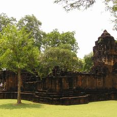
Mueang Sing historical park
11 km
Wang Pho Viaduct
471 m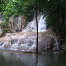
Sai Yok Noi waterfall
18.7 km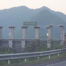
Tha Thung Na Dam
16 km
Tha Thung Na Reservoir
17.1 km
Tham Maduea
12.8 km
Lawa cave turn off
17.3 km
Prasat Mueang Sing Historical Park
11.2 km
Sai Yok Elephant Camp
2.2 km
Elephants World
17.4 km
Malika R.E.124
12.6 km
Elephant Haven Thailand
2.1 km
Ganeshapark
16.1 km
Tiger Temple
7.3 km
Water Source
18.9 km
Prasat Mueang Sing
11.2 km
The Nine Army Battle Historical Park
14.1 km
Death Railway
8 km
Taweechai Elephant Camp
14 km
Tiger head entry
8 km
Death Railway
270 m
Scenic viewpoint
15.7 km
Ancient City of Garuda
16.2 km
Burial Pit
11.5 km
Ruins
11.2 km
Ruins
11.2 km
น้ำตกไทรโยคน้อย
18.7 kmReviews
Visited this place? Tap the stars to rate it and share your experience / photos with the community! Try now! You can cancel it anytime.
Discover hidden gems everywhere you go!
From secret cafés to breathtaking viewpoints, skip the crowded tourist spots and find places that match your style. Our app makes it easy with voice search, smart filtering, route optimization, and insider tips from travelers worldwide. Download now for the complete mobile experience.

A unique approach to discovering new places❞
— Le Figaro
All the places worth exploring❞
— France Info
A tailor-made excursion in just a few clicks❞
— 20 Minutes