Wooden bridge
Location: จังหวัดแม่ฮ่องสอน
GPS coordinates: 18.83536,98.04666
Latest update: November 15, 2025 08:08
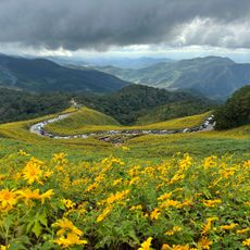
Thung Bua Tong Forest Park
8.1 km
Khun Yuam WW2 Japanese War Museum
12 km
Wat To Phae
15.6 km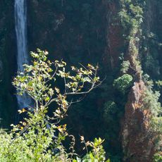
Mae Surin Falls
11.8 km
Wat Khum
11.6 km
Wat Mueang Pon
16.1 km
Wat Thamma Chedi Wanaran
17.1 km
Wat Pratu Mueang
21.1 km
Awesome view of the hills
17.6 km
Nice view, you can go with motorcycle
8.3 km
Scenic viewpoint
8.5 km
Mae Surin Waterfall Viewpoint
12 km
Scenic viewpoint
221 m
Misty Mountain Viewpoint
13 km
Saturday market
11.7 km
Sunset view point
12 km
High point 1500m
13.9 km
Thung Bua Tong
7.9 km
Mae Surin Waterfall Viewpoint
12 km
Lake
20.5 km
Vieuwpoint
20.3 km
จุดชมวิวเมืองปอน
15.9 km
Scenic viewpoint
8.2 km
Thung Bua Tong
8.2 km
Scenic viewpoint
11.3 km
Rice terraces viewpoint
10.8 km
Scenic viewpoint
13.7 km
Cascaden small
174 mReviews
Visited this place? Tap the stars to rate it and share your experience / photos with the community! Try now! You can cancel it anytime.
Discover hidden gems everywhere you go!
From secret cafés to breathtaking viewpoints, skip the crowded tourist spots and find places that match your style. Our app makes it easy with voice search, smart filtering, route optimization, and insider tips from travelers worldwide. Download now for the complete mobile experience.

A unique approach to discovering new places❞
— Le Figaro
All the places worth exploring❞
— France Info
A tailor-made excursion in just a few clicks❞
— 20 Minutes