Bouldering area
Location: จังหวัดนครราชสีมา
GPS coordinates: 14.81796,101.59362
Latest update: November 17, 2025 00:07
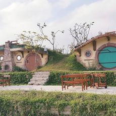
Baan hobbit
4 km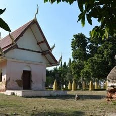
Wat Non Kum
16.1 km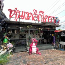
Dragon Cafe sculptures
19.5 km
Wat Thanon Khot
13.2 km
Lam Takhong reservoir
6.4 km
Ang Kep Nam Kap Pradu
10.6 km
Ang Kep Nam Nong Phrom
11.8 km
Ang Kep Nam Sap Makha Ngam
11 km
Wat Pa Ang Sap Pradu
11.5 km
ริมผามะแก้ว
6.4 km
ผาต้านลม
18.5 km
ศิลาฤกษ์
18.3 km
Tunnel
18.3 km
Fah Plai Rung Resort
11.6 km
Wat Pa Phupha Sung
18.2 km
Scenic viewpoint
13.3 km
Lam Takong Dam
6.4 km
Scenic viewpoint
11.3 km
Wat Ko
15.3 km
ผารากไทร
18.4 km
Scenic viewpoint
18.4 km
วิมานทิพย์
18.3 km
Scenic viewpoint
18.3 km
Jag's Big Rock
6.7 km
Scenic viewpoint
6.2 km
Scenic viewpoint
6.5 km
วัดสมเด็จโต
16.2 km
สะพานเขียวซับม่วง
16.5 kmReviews
Visited this place? Tap the stars to rate it and share your experience / photos with the community! Try now! You can cancel it anytime.
Discover hidden gems everywhere you go!
From secret cafés to breathtaking viewpoints, skip the crowded tourist spots and find places that match your style. Our app makes it easy with voice search, smart filtering, route optimization, and insider tips from travelers worldwide. Download now for the complete mobile experience.

A unique approach to discovering new places❞
— Le Figaro
All the places worth exploring❞
— France Info
A tailor-made excursion in just a few clicks❞
— 20 Minutes