The Big Tree
Location: Guildford
Location: Shire of Mount Alexander
GPS coordinates: -37.14886,144.16354
Latest update: November 22, 2025 15:19
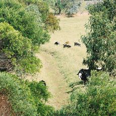
Keyline design
7.9 km
Castlemaine Diggings National Heritage Park
6.7 km
Castlemaine Cemetery
7 km
Sailors Gully Gold Mining Precinct
5.2 km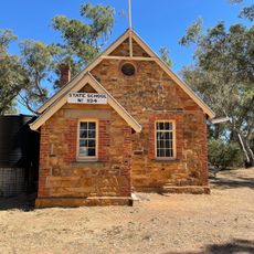
Former Common School No. 1124
6.4 km
Guildford Primary School No. 264
372 m
Marsh House
1.9 km
Deadmans Gully Burial Ground
6.3 km
Red Hill Hydraulic Gold Sluicing Site
5.3 km
Spring Gully Quartz Gold Mines
7.6 km
Vaughan Chinese Cemetery
4.4 km
Fryerstown Methodist Church Hall
7.8 km
Spring Gully Gold Puddling Site
6.9 km
Former Newstead Shire Chambers
7.2 km
Castlemaine Golf Club
7.6 km
Havelock Street Lookout
837 m
Tubal Cain Mine
6.2 km
Stones Gully
7.1 km
Sebastapol Gully
7.8 km
Spring Gully Mine
7.5 km
Spring Gully Mine
7.6 km
Spring Gully Mine
7.6 km
Ruins
5.5 km
Ruins
5.9 km
Cornish Chimney
6.2 km
Sangers Hut
7.9 km
Fryerstown War Memorial
7.8 km
Glenluce Falls
7 kmReviews
Visited this place? Tap the stars to rate it and share your experience / photos with the community! Try now! You can cancel it anytime.
Discover hidden gems everywhere you go!
From secret cafés to breathtaking viewpoints, skip the crowded tourist spots and find places that match your style. Our app makes it easy with voice search, smart filtering, route optimization, and insider tips from travelers worldwide. Download now for the complete mobile experience.

A unique approach to discovering new places❞
— Le Figaro
All the places worth exploring❞
— France Info
A tailor-made excursion in just a few clicks❞
— 20 Minutes