Thunderbolt's Cave
Location: Black Mountain
Location: Armidale Regional Council
GPS coordinates: -30.33037,151.67513
Latest update: November 21, 2025 17:33
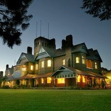
Booloominbah
17.8 km
Malpas Reservoir
8.7 km
Elizabeth Park
18.9 km
Vera Lovelock Park
17.3 km
Wicklow Oval
20.1 km
Aveliss Ellery Park
19.7 km
Mckie Park
12.8 km
White Park
12.8 km
Mother of Ducks Lagoon Nature Reserve
11.1 km
Fangorn
19 km
Work of art
20.2 km
Former Armidale Gasworks
20.1 km
The Armidale Playhouse
20 km
Black Cockatoos
20.2 km
Guyra Golf Course
11.6 km
Federation Viewing Platform
11.3 km
Scenic viewpoint
11.9 km
Apex Lookout
19.5 km
Scenic viewpoint
19.3 km
Lazenby Hall
17.6 km
David Henry Drummond
19.4 km
Memorial stone, memorial
19.1 km
Memorial stone, memorial
19 km
Memorial
19.1 km
Stele, memorial
18.8 km
Memorial, memorial stone
18.8 km
William Curtis
20.2 km
The Big Lamb
12.4 kmReviews
Visited this place? Tap the stars to rate it and share your experience / photos with the community! Try now! You can cancel it anytime.
Discover hidden gems everywhere you go!
From secret cafés to breathtaking viewpoints, skip the crowded tourist spots and find places that match your style. Our app makes it easy with voice search, smart filtering, route optimization, and insider tips from travelers worldwide. Download now for the complete mobile experience.

A unique approach to discovering new places❞
— Le Figaro
All the places worth exploring❞
— France Info
A tailor-made excursion in just a few clicks❞
— 20 Minutes