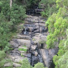
Wombelano Falls viewing platform
Location: Kinglake
Location: Shire of Murrindindi
GPS coordinates: -37.48078,145.34813
Latest update: November 22, 2025 18:41
Kinglake National Park
14.6 km
Toolangi State Forest
15.8 km
Disappointment Reference Area
17.1 km
Smedleys Falls
9.8 km
Mount Everard
11.1 km
Lobbs Hill
14.5 km
Yarra Ridge
16.6 km
Wrights Falls
2.9 km
Mount Slide
8.1 km
One Tree Hill
17.2 km
O'Connor Weir
3.6 km
Mount Beggary
8.8 km
High Bow Hill
16.5 km
Wallaby Weir
12.4 km
Smith Hill
12.4 km
Silver Weir
16.9 km
Scenic viewpoint
16 km
Masons Falls viewing platform
9.1 km
Lyrebird survey ceramics & carving
8.8 km
The Blacksmith's Tree
9.2 km
Kinglake Raspberries
3.8 km
Approx. site of Hume and Hovell camp 7 Dec 1824
16 km
Approx. site of Hume and Hovell camp 8 Dec 1824 and approx. route 10 Dec 1824
17.2 km
Approx. route of Hume and Hovell 9 Dec 1824
13.5 km
Black Saturday Bushfire Memorial
11 km
Strathewen Community Bushfire Memorial
9.2 km
St Andrews Bushfire Memorial
7.4 km
Masons Falls
9.1 kmReviews
Visited this place? Tap the stars to rate it and share your experience / photos with the community! Try now! You can cancel it anytime.
Discover hidden gems everywhere you go!
From secret cafés to breathtaking viewpoints, skip the crowded tourist spots and find places that match your style. Our app makes it easy with voice search, smart filtering, route optimization, and insider tips from travelers worldwide. Download now for the complete mobile experience.

A unique approach to discovering new places❞
— Le Figaro
All the places worth exploring❞
— France Info
A tailor-made excursion in just a few clicks❞
— 20 Minutes