Dundas Rocks dam
Location: Dundas
Location: Shire Of Dundas
GPS coordinates: -32.38852,121.77278
Latest update: November 22, 2025 22:27
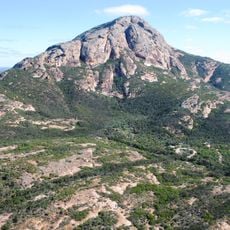
Peak Charles National Park
85 km
Ngadju Indigenous Protected Area
59.8 km
Ten Mile Rocks
89.9 km
Dundas Nature Reserve
83.6 km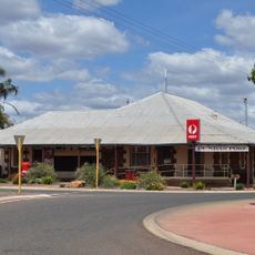
Norseman Post Office
21.2 km
Holy Trinity Church, Norseman
21 km
Stennet Rock
30.6 km
Salmon Gums Research Station
68.1 km
Doctor's House, Norseman
21.1 km
Truslove School Site
106.2 km
Work of art, sculpture
21.1 km
Salmon Gums Golf Club
67.7 km
Cave Hill
96.1 km
Sunday Soak
77.6 km
Nullarbor Links - "Sheep's Back"
104.5 km
Historic Dundas Town Site - Approx
726 m
Norseman Horse
21.3 km
Mural, Work of art
117.3 km
Norseman Golf Club
22.6 km
Beacon Hill lookout
21.7 km
Scenic viewpoint
22.8 km
Scenic viewpoint
21.4 km
Wave Rock
106 km
Kevin Lanceley
55.3 km
Peninsula Mine (Abandoned)
46.8 km
Wayside cross
14.5 km
Monument
84.8 km
Memorial
21.2 kmReviews
Visited this place? Tap the stars to rate it and share your experience / photos with the community! Try now! You can cancel it anytime.
Discover hidden gems everywhere you go!
From secret cafés to breathtaking viewpoints, skip the crowded tourist spots and find places that match your style. Our app makes it easy with voice search, smart filtering, route optimization, and insider tips from travelers worldwide. Download now for the complete mobile experience.

A unique approach to discovering new places❞
— Le Figaro
All the places worth exploring❞
— France Info
A tailor-made excursion in just a few clicks❞
— 20 Minutes