The Empire of Atlantium
Location: Reids Flat
Location: Hilltops Council
GPS coordinates: -34.16876,149.02907
Latest update: November 1, 2025 01:46

Lachlan Valley Railway
47.6 km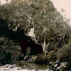
Abercrombie Caves
41.1 km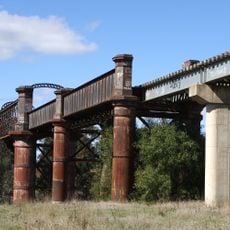
Lachlan River railway bridge, Cowra
47.7 km
Cowra Library
48.2 km
Boyds Lookout
25.5 km
Sheck Webster Lookout
19.2 km
Lachlan Valley Railway
47.5 km
Elliotts Lookout
27.7 km
Scenic viewpoint
24.4 km
Thompson's Lookout
24.7 km
Scenic viewpoint
24.2 km
Sheck Webster Lookout
19.2 km
Balancing Rock Lookout
24.6 km
Scenic viewpoint
40.4 km
World Peace Bell
48.4 km
Darby's Fall Observatory
31.3 km
Bald Rock Lookout
26.7 km
Scenic viewpoint
22.3 km
Scenic viewpoint
22.2 km
War Memorial
41.3 km
Trunkey Creek Memorial Wall
47.7 km
Memorial
41.2 km
Memorial
41.1 km
Memorial, war memorial
25 km
Commemorative plaque, memorial
35.2 km
Memorial
35.2 km
Memorial, war memorial
32.3 km
Memorial, war memorial
47.6 kmReviews
Visited this place? Tap the stars to rate it and share your experience / photos with the community! Try now! You can cancel it anytime.
Discover hidden gems everywhere you go!
From secret cafés to breathtaking viewpoints, skip the crowded tourist spots and find places that match your style. Our app makes it easy with voice search, smart filtering, route optimization, and insider tips from travelers worldwide. Download now for the complete mobile experience.

A unique approach to discovering new places❞
— Le Figaro
All the places worth exploring❞
— France Info
A tailor-made excursion in just a few clicks❞
— 20 Minutes