Historic mining tunnel
Location: Kevington
Location: Shire of Mansfield
GPS coordinates: -37.38126,146.22194
Latest update: November 22, 2025 18:32
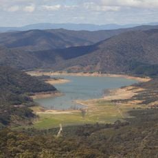
Lake Eildon National Park
23.1 km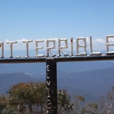
Mount Terrible
7.4 km
Tunnel Bend diversion tunnel
16 m
Mcadam Hill
23.5 km
Leichardt Gold Crushing Battery
21.7 km
Howqua United Gold Treatment Works
22.7 km
Stockyard Creek Gold Mining Diversion Sluice
23.3 km
Ruins
22.2 km
Ruins, mine shaft
22.5 km
Williams Lookout
15.7 km
Scenic viewpoint
11.8 km
Scenic viewpoint
15.9 km
Scenic Lookout
14.8 km
Mitchells Homestead
15.3 km
Mount Terrible
7.4 km
Water Wheel Mount
22.8 km
Howqua United Gold Treatment Works pyritic roasting furnace
23.1 km
Leichardt Gold Battery Ruins
21.8 km
Scenic viewpoint
24.7 km
Ruins, mine shaft
22.5 km
Historic Petrol Station
21.1 km
Cinnabar Mine
10.1 km
Prosecutors Hut
20.1 km
Pemburthy Township Site
20.3 km
Sir John Franklin Crusher Plant And Water Wheel (1860 - 1880)
22.4 km
Dusty’s Diversion Tunnel (1870’s)
21 km
All Nations Boiler and Chimney
24 km
Enoch Falls
11.7 kmReviews
Visited this place? Tap the stars to rate it and share your experience / photos with the community! Try now! You can cancel it anytime.
Discover hidden gems everywhere you go!
From secret cafés to breathtaking viewpoints, skip the crowded tourist spots and find places that match your style. Our app makes it easy with voice search, smart filtering, route optimization, and insider tips from travelers worldwide. Download now for the complete mobile experience.

A unique approach to discovering new places❞
— Le Figaro
All the places worth exploring❞
— France Info
A tailor-made excursion in just a few clicks❞
— 20 Minutes