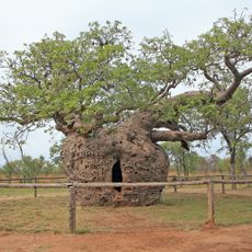
The Dinner Tree
Location: Derby
Location: Shire Of Derby-West Kimberley
GPS coordinates: -17.32274,123.63542
Latest update: November 24, 2025 02:12

Boab Prison Tree, Derby
4.6 km
Curtin Immigration Reception and Processing Centre
37.1 km
Liveringa
98.9 km
Dampier Hill
66.3 km
Mount Clarkson
43.6 km
Bells Tower
74 km
Mount Jowlaenga
75.6 km
Reeves Hill
68.3 km
Yarrada Hill
32.8 km
Bungarun (Leprosarium), Derby
12.3 km
Yampi Defence Area
96.7 km
Myall's Bore
4.6 km
Wharfingers House, Derby
2.7 km
Boulder Hill West Area
88.2 km
Derby Tramway Woolshed
2.7 km
Royal Flying Doctor Service, House and Office
1.6 km
Holman House
4 km
Derby Botanic Gardens
2.3 km
Oombalai Area
66.9 km
Derby Town Commonage
4.5 km
Derby Police Gaol
1.8 km
Lennard River
18.4 km
Horizontal Waterfalls
91.5 km
Gefängnisbaum
4.8 km
Mowanjum Art and Culture Center
7.4 km
Joonjoo Botanical trail
4.1 km
Norval Gallery
2.1 km
Bungarun Leprosarium (Derby Leper Colony)
5.1 kmReviews
Visited this place? Tap the stars to rate it and share your experience / photos with the community! Try now! You can cancel it anytime.
Discover hidden gems everywhere you go!
From secret cafés to breathtaking viewpoints, skip the crowded tourist spots and find places that match your style. Our app makes it easy with voice search, smart filtering, route optimization, and insider tips from travelers worldwide. Download now for the complete mobile experience.

A unique approach to discovering new places❞
— Le Figaro
All the places worth exploring❞
— France Info
A tailor-made excursion in just a few clicks❞
— 20 Minutes