Historic Manure Pits
Location: Brown Hill Creek
Location: Adelaide
GPS coordinates: -34.98688,138.64410
Latest update: November 6, 2025 13:21
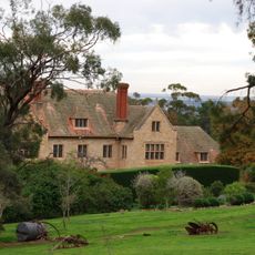
Carrick Hill
1.4 km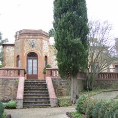
Old Government House
2.4 km
Brown Hill, Mitcham
669 m
Waite Arboretum
2.5 km
WWII
2.1 km
Mitcham Water Works
1.5 km
Work of art, sculpture
1.7 km
Scenic viewpoint
1.6 km
Lower Waterfall
2.3 km
Wylie Hill
1 km
Harold's Lookout
1.5 km
Logania Lookout
1.7 km
Netherby Spur
1.4 km
Scenic viewpoint
921 m
The Sacred Garden
2.4 km
Belair Maze
1.7 km
Old Toll House (1841)
2.4 km
Eagle Silver-Lead Mine
2.4 km
Ruins
2.5 km
Hardy Town
2.1 km
Brown Hill
673 m
Peter Nelson Walking Trail
1.6 km
Belair Maze
1.7 km
Auatralian Corroboree
2 km
Walter Gooch
2.2 km
The Greater Mount Lofty Parklands - Yurrebilla
2.5 km
Memorial, commemorative plaque
2.1 km
Lower Waterfall
2.3 kmReviews
Visited this place? Tap the stars to rate it and share your experience / photos with the community! Try now! You can cancel it anytime.
Discover hidden gems everywhere you go!
From secret cafés to breathtaking viewpoints, skip the crowded tourist spots and find places that match your style. Our app makes it easy with voice search, smart filtering, route optimization, and insider tips from travelers worldwide. Download now for the complete mobile experience.

A unique approach to discovering new places❞
— Le Figaro
All the places worth exploring❞
— France Info
A tailor-made excursion in just a few clicks❞
— 20 Minutes