Trojmedzie hraníc SK-PL-CZ
Location: Čierne
Location: okres Čadca
GPS coordinates: 49.51670,18.85087
Latest update: November 17, 2025 20:44
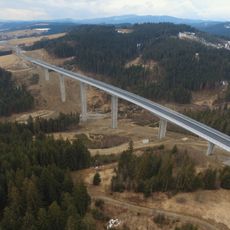
Valy Bridge
996 m
WOP post in Jaworzynka
1.9 km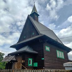
Church of Saints Cyril and Methodius
1.3 km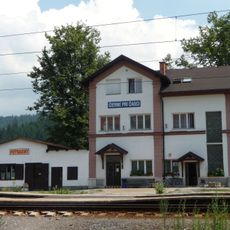
Čierne pri Čadci railway station
3.3 km
Muzeum Regionalne "Na Grapie" w Jaworzynce
3.5 km
Lípa přátelství
58 m
Čierne-Polesie railway stop
844 m
Čierne pri Čadci zastávka railway halt
863 m
Buk lesní na Husarově Grúni
947 m
Skupina stromů v Hrčavě
1.4 km
Dub letní na Hrčavě
1 km
Lurdská jeskyně Hrčava
1.6 km
Schodiště kostela sv. Cyrila a Metoděje
1.3 km
Maľba nástenná
3.5 km
Scenic viewpoint
3 km
Scenic viewpoint
3.5 km
4. Tečie, voda tečie
2.8 km
Cintorín odpadkov
2.8 km
Scenic viewpoint
2.3 km
Scenic viewpoint
2.3 km
Trójstyk granic PL-SK-CZ
76 m
Mały Szaniec
1.1 km
Scenic viewpoint
757 m
Památník posledního vlka v Beskydech
2.6 km
Wayside shrine
188 m
Catholic church building, wayside cross, Christianity
231 m
Wayside cross
1.2 km
Święty obrázek
1.3 kmReviews
Visited this place? Tap the stars to rate it and share your experience / photos with the community! Try now! You can cancel it anytime.
Discover hidden gems everywhere you go!
From secret cafés to breathtaking viewpoints, skip the crowded tourist spots and find places that match your style. Our app makes it easy with voice search, smart filtering, route optimization, and insider tips from travelers worldwide. Download now for the complete mobile experience.

A unique approach to discovering new places❞
— Le Figaro
All the places worth exploring❞
— France Info
A tailor-made excursion in just a few clicks❞
— 20 Minutes