Public lavatory
Location: La Roche-Canillac
GPS coordinates: 45.19663,1.97066
Latest update: November 15, 2025 11:28

Église Saint-Maur de La Roche-Canillac
85 m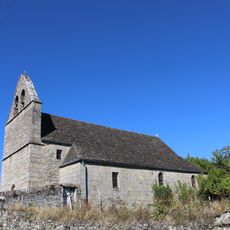
Église Saint-Pierre de Champagnac-la-Prune
1.9 km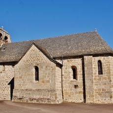
Église Saint-Pierre-ès-Liens de Gumond
2.7 km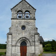
Église Saint-Étienne de Gros-Chastang
2.2 km
Croix de chemin de Saint-Martin-la-Méanne
3.3 km
Scenic viewpoint
856 m
Scenic viewpoint
561 m
Scenic viewpoint
1.8 km
Laplaze
3.3 km
Wayside cross
2.7 km
Rocher de Julia
506 m
Work of art, sculpture
1.9 km
Work of art, sculpture
2.7 km
Castle
436 m
Lavoir
345 m
Wayside cross
3.3 km
Wayside cross
2.5 km
Rocher de Charlemagne
530 m
Wayside cross
1.6 km
Wayside cross
1.7 km
Kévin Pereire
3.3 km
Robert Perperot
3.2 km
Wayside cross
2.1 km
Memorial, war memorial
3.1 km
Wayside cross
3.1 km
Wayside cross
3.1 km
Wayside cross
2.6 km
Cascade du Perbos
2.4 kmReviews
Visited this place? Tap the stars to rate it and share your experience / photos with the community! Try now! You can cancel it anytime.
Discover hidden gems everywhere you go!
From secret cafés to breathtaking viewpoints, skip the crowded tourist spots and find places that match your style. Our app makes it easy with voice search, smart filtering, route optimization, and insider tips from travelers worldwide. Download now for the complete mobile experience.

A unique approach to discovering new places❞
— Le Figaro
All the places worth exploring❞
— France Info
A tailor-made excursion in just a few clicks❞
— 20 Minutes