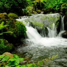
Tsablnari Waterfall
Location: ქობულეთის მუნიციპალიტეტი
GPS coordinates: 41.67055,41.87795
Latest update: November 18, 2025 17:40
Mtirala National Park
686 m
Colchic Rainforests and Wetlands
7 km
Საღორეთის (აგარის) ხიდი
8.6 km
Skala Melis-Tsikhe
5 km
Ზენდიდის ეკლესია
8.6 km
Ყალივაკის ციხე
6.2 km
Shuamta Raptor Watchpoint
8.5 km
Scenic viewpoint
538 m
Zip line
1 km
Gulebi fortress
7.6 km
Keda Top
8.2 km
Scenic viewpoint
8.5 km
Scenic viewpoint
7.6 km
Scenic viewpoint
8.8 km
Rope park (not functioning)
868 m
Scenic viewpoint
3.9 km
Scenic viewpoint
3.8 km
BRC Shuamta Raptor Watchpoint
8.4 km
Fortress
9.1 km
Საღორეთის (კლდისთავი) ციხე
8.5 km
Memorial of plane crash
8 km
Ruins
838 m
Waterfall
2 km
Waterfall
7.2 km
Waterfall
7 km
Waterfall
7 km
Waterfall
6.8 km
Waterfall
6.5 kmReviews
Visited this place? Tap the stars to rate it and share your experience / photos with the community! Try now! You can cancel it anytime.
Discover hidden gems everywhere you go!
From secret cafés to breathtaking viewpoints, skip the crowded tourist spots and find places that match your style. Our app makes it easy with voice search, smart filtering, route optimization, and insider tips from travelers worldwide. Download now for the complete mobile experience.

A unique approach to discovering new places❞
— Le Figaro
All the places worth exploring❞
— France Info
A tailor-made excursion in just a few clicks❞
— 20 Minutes