Historical Bridge of the XII Century
Location: ხელვაჩაურის მუნიციპალიტეტი
GPS coordinates: 41.56380,41.67139
Latest update: November 13, 2025 12:15

Ერგეს ხიდი
3.7 km
Მახოს ციხე-კოშკი
8 m
Მახოს ხიდი
8 m
Მირვეთის ხიდი
5.2 km
Pedestrian bridge
1 km
Mirveti Arch Bridge
5.2 km
Confluence of two rivers
3.7 km
Scenic viewpoint
1.9 km
The confluence of two rivers
4.6 km
Scenic viewpoint
4.8 km
Scenic viewpoint
1.5 km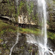
Jocho waterfall
4.3 km
Scenic viewpoint
3.9 km
Მირვეთის ციხე
5.1 km
1941-1945
3.7 km
Პოლიტიკური რეპრესიების მსხვერპლთა ხსოვნის მემორიალი
1.8 km
1989 წლის 9 აპრილს თბილისში დაღუპულთა სახსოვარი
1.8 km
Უკვდავი ერის შვილი მამულისათვის მომკვდარი 1941-1945
2.6 km
Memorial, war memorial
1.5 km
Memorial, war memorial
3.4 km
1989 წლის 19 აპრილს აჭარის მთიანეთში სტიქიით დაღუპულთა ხსოვნის ხეივანი
1.8 km
Waterfall, tourist attraction
1.2 km
Მირვეთის ჩანჩქერი
4.9 km
Waterfall
4.4 km
Waterfall
4 km
Waterfall
3.2 km
Waterfall
574 m
Love waterfall
4.3 kmReviews
Visited this place? Tap the stars to rate it and share your experience / photos with the community! Try now! You can cancel it anytime.
Discover hidden gems everywhere you go!
From secret cafés to breathtaking viewpoints, skip the crowded tourist spots and find places that match your style. Our app makes it easy with voice search, smart filtering, route optimization, and insider tips from travelers worldwide. Download now for the complete mobile experience.

A unique approach to discovering new places❞
— Le Figaro
All the places worth exploring❞
— France Info
A tailor-made excursion in just a few clicks❞
— 20 Minutes