Keltischer Baumkreis
Location: Grunern
Location: Staufen im Breisgau
GPS coordinates: 47.86604,7.73298
Latest update: October 11, 2024 03:27
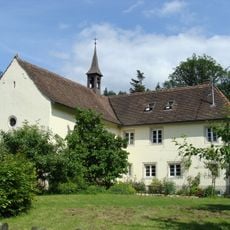
Johanneskapelle
1.3 km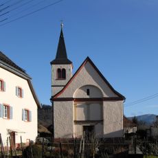
St. Agatha
954 m
Katzenstuhl
1.2 km
1 Traubeneiche Hohacker
698 m
4 Blutbuchen
805 m
3 Esskastanien
978 m
Boeckfelsen (370)
1.2 km
Wayside cross
1.3 km
Wayside cross
955 m
Scenic viewpoint
960 m
St. Barbara
941 m
Alte Trotte
980 m
Wayside cross
1.1 km
Wayside cross
706 m
Wayside cross
703 m
Scenic viewpoint
1.3 km
Wayside cross
654 m
Messerschmiedfelsen
943 m
Wayside shrine, Christianity, Catholic church building
1.3 km
Christianity, Catholic church building, wayside shrine
1.3 km
Wayside shrine
1.3 km
Catholic church building, wayside shrine, Christianity
1.3 km
Wayside cross
1.3 km
Wayside cross
1.3 km
Catholic church building, wayside shrine, Christianity
1.3 km
Wayside shrine, Christianity, Catholic church building
1.3 km
Wayside shrine, Christianity, Catholic church building
1.4 km
Wayside cross
1.4 kmReviews
Visited this place? Tap the stars to rate it and share your experience / photos with the community! Try now! You can cancel it anytime.
Discover hidden gems everywhere you go!
From secret cafés to breathtaking viewpoints, skip the crowded tourist spots and find places that match your style. Our app makes it easy with voice search, smart filtering, route optimization, and insider tips from travelers worldwide. Download now for the complete mobile experience.

A unique approach to discovering new places❞
— Le Figaro
All the places worth exploring❞
— France Info
A tailor-made excursion in just a few clicks❞
— 20 Minutes