Schinderhannesloch
Location: Bad Münster am Stein-Ebernburg
Location: Bad Kreuznach
GPS coordinates: 49.79893,7.79774
Latest update: November 20, 2025 05:02
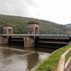
Stausee Niederhausen
1 km
Jüdischer Friedhof Siefersheim
234 m
Bruderhaus, später Reguliertes Schwesternhaus (Augustinerinnenkloster), dann Franziskanertertiarinnen-Konvent Trombach
553 m
Golfclub Nahetal
1 km
Tree, Work of art
1.5 km
Tree, Work of art
1.5 km
Tree, Work of art
1.5 km
Tree, Work of art
1.4 km
Tree, Work of art
1.4 km
Tree, Work of art
1.3 km
Tree, Work of art
1.3 km
Work of art, tree
1.3 km
Work of art
1 km
Work of art, sculpture
5 m
Scenic viewpoint, dead end street
1.4 km
Scenic viewpoint
815 m
Scenic viewpoint
650 m
Scenic viewpoint
350 m
Scenic viewpoint
863 m
Scenic viewpoint
1.1 km
Barbarablick
1.4 km
Scenic viewpoint
1.3 km
Stauseeblick
1 km
Wayside cross
1.3 km
Trombacher Hof
573 m
Wayside cross
935 m
Wayside shrine, Christianity
961 m
Catholic church building, wayside shrine, Christianity
1.4 kmReviews
Visited this place? Tap the stars to rate it and share your experience / photos with the community! Try now! You can cancel it anytime.
Discover hidden gems everywhere you go!
From secret cafés to breathtaking viewpoints, skip the crowded tourist spots and find places that match your style. Our app makes it easy with voice search, smart filtering, route optimization, and insider tips from travelers worldwide. Download now for the complete mobile experience.

A unique approach to discovering new places❞
— Le Figaro
All the places worth exploring❞
— France Info
A tailor-made excursion in just a few clicks❞
— 20 Minutes