Rotes Männle
Location: Hohentengen am Hochrhein
GPS coordinates: 47.57289,8.45784
Latest update: November 21, 2025 22:04
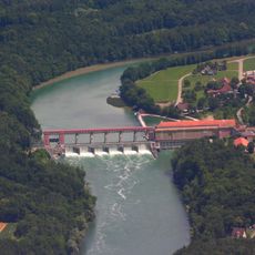
Eglisau-Glattfelden Power Station
1.2 km
Rheinsfelden
1.1 km
Hardwald
321 m
Fasnachtfluh, prähistorische Wallanlage
2 km
Stein, befestigte Gebäuderuine und Wörndel / Leuenkopf, Wallanlage
1.6 km
Warte Heidenbuck
1.9 km
Leebern
2 km
Work of art, sculpture
1.6 km
Work of art, sculpture
1.6 km
Work of art, sculpture
1.6 km
Work of art, sculpture
1.6 km
Work of art, sculpture
1.6 km
Work of art, sculpture
1.6 km
Work of art, sculpture
1.6 km
Ein Ring aus Stahl
453 m
Work of art, sculpture
1.6 km
Sculpture, Work of art
1.6 km
Work of art, sculpture
1.6 km
Sculpture, Work of art
1.6 km
Sculpture, Work of art
1.6 km
Sculpture, Work of art
1.7 km
Leuenchopf
1.6 km
Kriegerdenkmal
1.9 km
Wayside cross
1.9 km
Wayside cross, Christianity, Catholic church building
1.2 km
Christianity, Catholic church building, wayside cross
1.7 km
Wayside cross
1.7 km
Waterfall
677 mReviews
Visited this place? Tap the stars to rate it and share your experience / photos with the community! Try now! You can cancel it anytime.
Discover hidden gems everywhere you go!
From secret cafés to breathtaking viewpoints, skip the crowded tourist spots and find places that match your style. Our app makes it easy with voice search, smart filtering, route optimization, and insider tips from travelers worldwide. Download now for the complete mobile experience.

A unique approach to discovering new places❞
— Le Figaro
All the places worth exploring❞
— France Info
A tailor-made excursion in just a few clicks❞
— 20 Minutes