Teleferik İstasyonu
Location: Şarkiye Mahallesi
GPS coordinates: 40.98470,37.88568
Latest update: October 27, 2025 12:39

Ulugöl Nature Park
48.7 km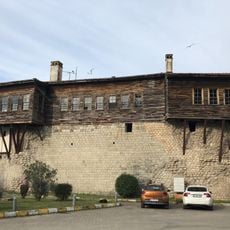
Bolaman Castle
25.4 km
Fatsa Lunapark
33.4 km
Yason Burnu
23.9 km
Tarihi Bakırcılar Sokağı
52.9 km
Kefeli Han
52.8 km
Kadılar Yokuşu
53 km
Ters Ev
100 m
Timsah adası
24.4 km
Yalancı Yason
24 km
Sarayburnu
22.6 km
Abdullah Bey Konağı
25.4 km
Kurul Castle
9.5 km
Ordu Boztepe Tesisleri & Mesire Alanı
2.4 km
Hoynat Adası Gözlem Bölgesi
19.8 km
Elephants trees
329 m
Plane and man
554 m
Atatürk Anıtı
52.9 km
Work of art, statue
475 m
Harmanada Ihlamuru
21.5 km
Kordontepe
13.4 km
Waterfall
17.4 km
Scenic viewpoint
42.7 km
Scenic viewpoint
43 km
Scenic viewpoint
42.9 km
Boztepe Seyir
2.3 km
Hoynat Adası Seyir Noktası
19.6 km
Scenic viewpoint
43.2 kmReviews
Visited this place? Tap the stars to rate it and share your experience / photos with the community! Try now! You can cancel it anytime.
Discover hidden gems everywhere you go!
From secret cafés to breathtaking viewpoints, skip the crowded tourist spots and find places that match your style. Our app makes it easy with voice search, smart filtering, route optimization, and insider tips from travelers worldwide. Download now for the complete mobile experience.

A unique approach to discovering new places❞
— Le Figaro
All the places worth exploring❞
— France Info
A tailor-made excursion in just a few clicks❞
— 20 Minutes