Sotomayor Nariño
Location: Los Andes Sotomayor
GPS coordinates: 1.50386,-77.54650
Latest update: November 15, 2025 15:30
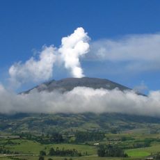
Galeras
37.7 km
Sagrado Corazón, Pasto
43.7 km
Cerro Morazurco
42.8 km
San Andrés
43.5 km
Galeras Fauna and Flora Sanctuary
38.1 km
Cañada Yunga
28.7 km
Parque Infantil
43.3 km
University of Narino Observatory
43.1 km
Altar mayor
43.8 km
Work of art, sculpture
43.8 km
Tunnel
24.9 km
Virgen de Cumbitara
30.2 km
Teatro Imperial
43.6 km
Altar del Cristo de la Agonía
43.8 km
Circo Valentinos
42.2 km
Altar de San Ezequiel Moreno
43.8 km
Estatua Juan Pablo Segundo
42.5 km
Maragato
32.9 km
Work of art, sculpture
43.8 km
Mirador
34.1 km
Mirador La Loma
33.7 km
La piedra del amor
30.5 km
Scenic viewpoint
35.9 km
Scenic viewpoint
37.1 km
Scenic viewpoint
37.2 km
Cascada el Guilque
29.8 km
Cascada de Belén
26 km
Cascada de Mijitayo
42.4 kmVisited this place? Tap the stars to rate it and share your experience / photos with the community! Try now! You can cancel it anytime.
Discover hidden gems everywhere you go!
From secret cafés to breathtaking viewpoints, skip the crowded tourist spots and find places that match your style. Our app makes it easy with voice search, smart filtering, route optimization, and insider tips from travelers worldwide. Download now for the complete mobile experience.

A unique approach to discovering new places❞
— Le Figaro
All the places worth exploring❞
— France Info
A tailor-made excursion in just a few clicks❞
— 20 Minutes