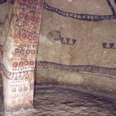
Alto del Aguacate
Location: Inzá
Opening Hours: Montag-Sonntag 08:00-16:00
GPS coordinates: 2.56730,-76.04894
Latest update: November 11, 2025 00:34
Tierradentro
2.5 km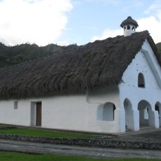
Capilla Paéz San Andrés de Pisimbalá
1.8 km
Chapelle páez Togoima
5.2 km
Cinturón Andino
24 km
Pitayo quesos y truchas
34.7 km
El Hato archeological site
2.1 km
Libertador’s bridge
37.5 km
Snake Waterfall
36.6 km
Tunnel
2 km
Cueva Caja de Agua
33.9 km
La azufrada
29.1 km
Parque Arqueologico de Tierradentro
1.5 km
Alto de Segovia
1.9 km
Alto del Duende
2.5 km
El Tablon
1.9 km
Alto de San Andrés
1.2 km
I Love Silvia
37.1 km
La Plata
26.6 km
Mirador
18 km
Scenic viewpoint
28.4 km
Vda San Pedro
10.8 km
Scenic viewpoint, shelter
1.7 km
Scenic viewpoint, shelter
1.7 km
Bench, scenic viewpoint
1.4 km
Scenic viewpoint
571 m
Scenic viewpoint
807 m
Cascada La Azufrada
29.1 km
Cascada la Serpiente
36.4 kmReviews
Visited this place? Tap the stars to rate it and share your experience / photos with the community! Try now! You can cancel it anytime.
Discover hidden gems everywhere you go!
From secret cafés to breathtaking viewpoints, skip the crowded tourist spots and find places that match your style. Our app makes it easy with voice search, smart filtering, route optimization, and insider tips from travelers worldwide. Download now for the complete mobile experience.

A unique approach to discovering new places❞
— Le Figaro
All the places worth exploring❞
— France Info
A tailor-made excursion in just a few clicks❞
— 20 Minutes