Quellflur bei Grueb, protected area of Upper Austria, Austria
Location: Tiefgraben
Inception: 2017
GPS coordinates: 47.87743,13.29906
Latest update: November 19, 2025 00:03

Lehmberg
3.1 km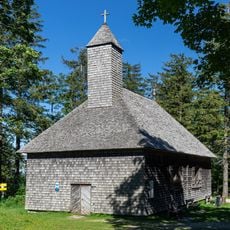
Filialkirche St. Koloman, Kolomansberg
1.6 km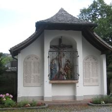
Kriegerdenkmal Zell am Moos
3.1 km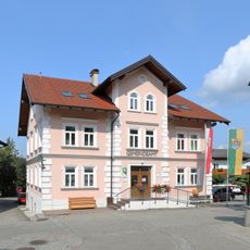
Municipal office
3.1 km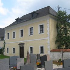
Pfarrhof
3.1 km
Feldinger Moor
2.4 km
Zwei Eichen in Tiefgraben
3.1 km
Eibe von Tiefgraben
2.4 km
Scenic viewpoint
2.5 km
Wayside cross
2.4 km
Badeplatz Tiefgraben
2 km
Phyllotaxis - Selleriestange
1.5 km
Work of art, sculpture
3.1 km
MondSeeLand-Blick
1.5 km
Free swimming spot
2.9 km
Wayside shrine
2.3 km
Wayside shrine
3.1 km
Badeplatz Dorferwirt
3 km
Wayside shrine
1.5 km
Wayside cross
1.6 km
Historic carving
2.6 km
Goldene Kutsche
3.1 km
Toter Mann
2.9 km
Kolomanstaferl
2.7 km
Kapelle
1.5 km
Matthias Gaderer Gedenkkreuz
3.1 km
Wayside cross
3.1 km
Wayside cross
1.7 kmReviews
Visited this place? Tap the stars to rate it and share your experience / photos with the community! Try now! You can cancel it anytime.
Discover hidden gems everywhere you go!
From secret cafés to breathtaking viewpoints, skip the crowded tourist spots and find places that match your style. Our app makes it easy with voice search, smart filtering, route optimization, and insider tips from travelers worldwide. Download now for the complete mobile experience.

A unique approach to discovering new places❞
— Le Figaro
All the places worth exploring❞
— France Info
A tailor-made excursion in just a few clicks❞
— 20 Minutes