Öffentliches Bad
Location: Falkenberg
Operator: Gemeinde Falkenberg
GPS coordinates: 48.49894,12.76786
Latest update: March 12, 2025 20:29
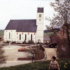
St. Ulrich
760 m
Feldkapelle
613 m
Hofkapelle
604 m
Kapelle
698 m
Cultural heritage D-2-7542-0016 in Falkenberg
1.7 km
Stockhaus in einem Dreiseithof
2.1 km
Cultural heritage D-2-7542-0103 in Falkenberg (Niederbayern)
764 m
Stockhaus eines Vierseithofes
2.2 km
Cultural heritage D-2-7442-0040 in Arnstorf
1.6 km
Scheune Zeilling 1 in Arnstorf
1.1 km
Cultural heritage D-2-7542-0018 in Falkenberg (Niederbayern)
1.4 km
Stockhaus eines Vierseithofes
2 km
Stockhaus eines Vierseithofes
1.1 km
Stockhaus
1.4 km
Einfirsthof mit verputztem Blockbau
1.9 km
Ehem. Stockhaus eines Dreiseithofes
772 m
Stockhaus eines Dreiseithofes
2.2 km
Ehem. Stockhaus der Hofanlage
516 m
Zugehörig Stadel
2.1 km
Mittertennbau
2.1 km
Zugehörig Stadel
599 m
Wayside shrine
1.7 km
Wayside cross
1.8 km
Wayside cross
1.7 km
Wayside cross
2.1 km
Wayside cross
1.7 km
Wayside shrine
915 m
Wayside cross
493 mReviews
Visited this place? Tap the stars to rate it and share your experience / photos with the community! Try now! You can cancel it anytime.
Discover hidden gems everywhere you go!
From secret cafés to breathtaking viewpoints, skip the crowded tourist spots and find places that match your style. Our app makes it easy with voice search, smart filtering, route optimization, and insider tips from travelers worldwide. Download now for the complete mobile experience.

A unique approach to discovering new places❞
— Le Figaro
All the places worth exploring❞
— France Info
A tailor-made excursion in just a few clicks❞
— 20 Minutes