Bunga Beach
Location: Murrah
Location: Bega Valley Shire Council
GPS coordinates: -36.56103,150.06027
Latest update: November 30, 2024 21:18
Penders
8.6 km
Ness, Wapengo
6.8 km
Penders Beach
8.7 km
Cuttagee Beach
7 km
Middle Beach
10.6 km
Baragoot Beach
8.9 km
Bunga Beach
1.6 km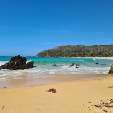
Armonds Bay
5.7 km
Gillards Beach
11.9 km
Murrah Beach
3.3 km
Aragunnu Beach
3.3 km
Mill Beach
7 km
Picnic Beach
6.5 km
Ginns Lookout
5.6 km
Goalen Head South
712 m
Picnic Point South
7.1 km
Bithry Inlet North
7.6 km
Scenic viewpoint, bench
8.3 km
Bunga South
1.2 km
Penders
8.6 km
Scenic viewpoint
2.5 km
Bengunnu Point South 1
5.1 km
Baragoot Beach
9.7 km
Bengunnu Point North
5 km
Middle Beach
10.9 km
Scenic viewpoint
11.6 km
Scenic viewpoint
2.6 km
Scenic viewpoint
11.9 kmReviews
Visited this place? Tap the stars to rate it and share your experience / photos with the community! Try now! You can cancel it anytime.
Discover hidden gems everywhere you go!
From secret cafés to breathtaking viewpoints, skip the crowded tourist spots and find places that match your style. Our app makes it easy with voice search, smart filtering, route optimization, and insider tips from travelers worldwide. Download now for the complete mobile experience.

A unique approach to discovering new places❞
— Le Figaro
All the places worth exploring❞
— France Info
A tailor-made excursion in just a few clicks❞
— 20 Minutes