Plage de Alle
Location: Alle
Location: Vresse-sur-Semois
GPS coordinates: 49.84712,4.97657
Latest update: November 16, 2025 17:57
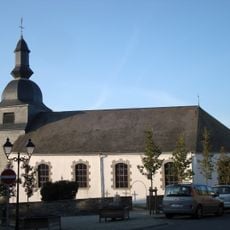
Église Saint-Firmin de Rochehaut
2.2 km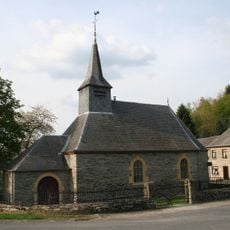
Chapelle Saint-Monon de Cornimont
2.3 km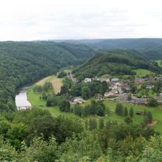
Meander of the Semois river at Frahan
2 km
Scenic viewpoint
2.1 km
Scenic viewpoint
293 m
Scenic viewpoint
1.2 km
Naglemont
1.5 km
Laspote Laviau
2.5 km
Scenic viewpoint
1.9 km
Scenic viewpoint
2.2 km
Scenic viewpoint
2.8 km
Point de vue des Corbeaux
1.7 km
Scenic viewpoint
722 m
Scenic viewpoint
434 m
Château Montragut
2.4 km
Moulin de Gros-Fays
2.8 km
Train parc animalier
2.2 km
Work of art, statue
2.2 km
Statue, Work of art
2.5 km
Work of art, statue
2.1 km
Scenic viewpoint
2 km
1914-1918
711 m
Wayside shrine, Christianity, house of prayer, Catholic church building, place of worship
2.5 km
Wayside cross
2.8 km
Stele, memorial
717 m
Wayside cross
2.4 km
Château Montragut
2.8 km
Wayside cross, Christianity, Catholic church building
2 kmReviews
Visited this place? Tap the stars to rate it and share your experience / photos with the community! Try now! You can cancel it anytime.
Discover hidden gems everywhere you go!
From secret cafés to breathtaking viewpoints, skip the crowded tourist spots and find places that match your style. Our app makes it easy with voice search, smart filtering, route optimization, and insider tips from travelers worldwide. Download now for the complete mobile experience.

A unique approach to discovering new places❞
— Le Figaro
All the places worth exploring❞
— France Info
A tailor-made excursion in just a few clicks❞
— 20 Minutes