Kotaluodon uimaranta
Location: Kerimäki
Location: Savonlinna
GPS coordinates: 61.91746,29.30903
Latest update: November 16, 2025 19:25
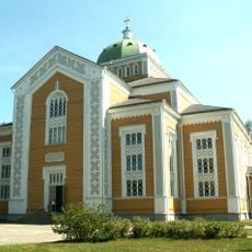
Kerimäki Church
1.4 km
Veneenniemen salpa-asema
454 m
Kerimäen kirkko ja kirkkoranta
1.7 km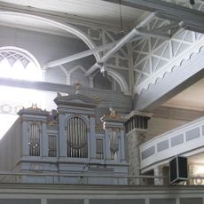
Kerimäki church organ
1.4 km
Hytermä
4.5 km
Karsikkokiventie
3.6 km
Kirkkoranta
1.6 km
Karsikkokivi (bato sa Finlandia, Savonlinna)
3.5 km
Lehmiahonsuo
4.7 km
Ylätalo
928 m
Itikkakallio
4.9 km
Metsälä
3.4 km
Keskotupa
5.1 km
Syvänotko
3.8 km
Sinikivi
2.7 km
Pihlastie
2.5 km
Kerimäki 370 vuotta
1.5 km
Kirkkorannan uimaranta
1.5 km
Memorial
1.6 km
Memorial
1.4 km
Memorial
4.5 km
Archaeological site
3.3 km
Archaeological site
3.5 km
Archaeological site
928 m
Archaeological site
2.5 km
Archaeological site
4.4 km
Sankaripatsas
1.6 km
Muikkupatsas
1.5 kmReviews
Visited this place? Tap the stars to rate it and share your experience / photos with the community! Try now! You can cancel it anytime.
Discover hidden gems everywhere you go!
From secret cafés to breathtaking viewpoints, skip the crowded tourist spots and find places that match your style. Our app makes it easy with voice search, smart filtering, route optimization, and insider tips from travelers worldwide. Download now for the complete mobile experience.

A unique approach to discovering new places❞
— Le Figaro
All the places worth exploring❞
— France Info
A tailor-made excursion in just a few clicks❞
— 20 Minutes