PLAYAS NEGRAS
Location: Municipio de La Unión
GPS coordinates: 13.16161,-87.94310
Latest update: November 23, 2025 18:23
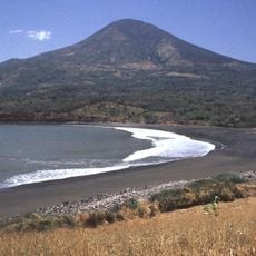
Volcán de Conchagua
18.1 km
Punta Amapala Lighthouse
4.8 km
Playa El Cuco
17 km
Playa El Flor
15.3 km
Playas Negras
366 m
Playa Blanca
1.7 km
Playa El Zapote
11.2 km
Playa El Jaguey
3.5 km
Playa El Tamarindo
5 km
Playa El Flor
813 m
Playa Torola
2.5 km
Playa Las Tunas
3.5 km
El Esteron Rancho Osorio Arbaiza Playa El Cuco
15.5 km
ENCANTADITO TOROLA
1.6 km
Playa Las Flores
18.4 km
Playa El Cuco
18.2 km
Punta de Amapala
5.1 km
Punta Las Mueludas
4.8 km
Punta Pedrero
2.5 km
Playa El Esteron
14.2 km
Playa Torola
2.3 km
Playa El cuco
17.8 km
Playa El cuco
17.3 km
Playa el cuco
16.8 km
Playa el cuco
14.7 km
PLAYAS LAS TUNAS
3 km
El Espíritu de la Montaña
16.9 km
Mirador de las Flores
18.3 kmReviews
Visited this place? Tap the stars to rate it and share your experience / photos with the community! Try now! You can cancel it anytime.
Discover hidden gems everywhere you go!
From secret cafés to breathtaking viewpoints, skip the crowded tourist spots and find places that match your style. Our app makes it easy with voice search, smart filtering, route optimization, and insider tips from travelers worldwide. Download now for the complete mobile experience.

A unique approach to discovering new places❞
— Le Figaro
All the places worth exploring❞
— France Info
A tailor-made excursion in just a few clicks❞
— 20 Minutes