Stoneline
Location: Innerschwand am Mondsee
GPS coordinates: 47.81292,13.39738
Latest update: July 20, 2025 13:51
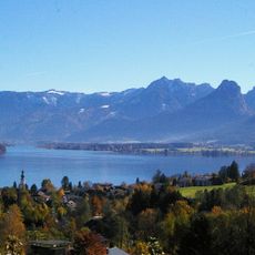
Salzkammergut Mountains
1.6 km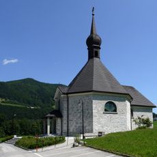
Filialkirche Innerschwand am Mondsee
2.1 km
Eglsee samt angrenzender Niedermoorflächen
1.8 km
Mündungsbereich der Fuschler-Ache
2.4 km
Pichlwald in Loibichl
702 m
Feuchtbodensiedlung Scharfling
1.6 km
Pfahlbaustation Scharfling
1.6 km
Pfahlbaustationen Scharfling, See und Mooswinkel
1.6 km
Tausendjährige Linde bei St. Lorenz
2.1 km
Mondsee, Seeufersiedlung Mosswinkel (Uferbereich)
524 m
Villa Lehmann
1.5 km
Pfahlbaustation Mooswinkel
409 m
Scenic viewpoint
2.1 km
Almkogel
2.5 km
Brandlberg
1.9 km
Salzkammergutlokalbahn-Ersatzstraße Denkmal Harnischwand
1.6 km
Wayside cross
2.3 km
Badeplatz Plomberg
2.4 km
Kreuzstein
2.4 km
Wayside cross
1.5 km
Scenic viewpoint
2.5 km
Badeplatz Innerschwand
2 km
Scenic viewpoint
2.6 km
Scenic viewpoint
2.6 km
Wayside cross
2.6 km
Wayside shrine, Christianity
2.6 km
Salzleckstelle
2.7 km
Work of art
2.7 kmReviews
Visited this place? Tap the stars to rate it and share your experience / photos with the community! Try now! You can cancel it anytime.
Discover hidden gems everywhere you go!
From secret cafés to breathtaking viewpoints, skip the crowded tourist spots and find places that match your style. Our app makes it easy with voice search, smart filtering, route optimization, and insider tips from travelers worldwide. Download now for the complete mobile experience.

A unique approach to discovering new places❞
— Le Figaro
All the places worth exploring❞
— France Info
A tailor-made excursion in just a few clicks❞
— 20 Minutes