Levensboom
Location: Hechtel
Location: Hechtel-Eksel
Creator: Boud Ceysens
GPS coordinates: 51.12512,5.36764
Latest update: November 25, 2025 18:19

Sint-Lambertuskerk
231 m
Tank memorial
291 m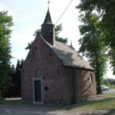
Sint-Bernarduskapel
1.8 km
Bosmuseum Pijnven
355 m
Scenic viewpoint
1.8 km
Scenic viewpoint
893 m
Sherman firefly tank
386 m
Sterrenboom
1.7 km
Hechtel aan zijn missionarissen
253 m
Hechtel aan zijne helden 1914-1918
223 m
Onze Lieve Vrouw van Rust
1.1 km
Pater Jan Mallet
414 m
Veldkapel
1.5 km
Christianity, wayside shrine
1.6 km
Lochterschans
1.8 km
Wayside shrine
536 m
Veldkapel
560 m
Wayside shrine
2.4 km
Wayside shrine
2.3 km
Wayside shrine
1.4 km
Wayside shrine
1.5 km
Wayside shrine
378 m
Cap. John Thornycroft
1.4 km
Wayside shrine
1.1 km
Catholic church building, wayside shrine, Christianity
1.1 km
Wayside shrine
1.1 km
Wayside shrine
2.4 km
Sherman firefly tank
386 mVisited this place? Tap the stars to rate it and share your experience / photos with the community! Try now! You can cancel it anytime.
Discover hidden gems everywhere you go!
From secret cafés to breathtaking viewpoints, skip the crowded tourist spots and find places that match your style. Our app makes it easy with voice search, smart filtering, route optimization, and insider tips from travelers worldwide. Download now for the complete mobile experience.

A unique approach to discovering new places❞
— Le Figaro
All the places worth exploring❞
— France Info
A tailor-made excursion in just a few clicks❞
— 20 Minutes