Citius, altius, fortius
Location: Raisio
Inception: January 1, 1988
Creator: Kerttu Horila
Creator: Kerttu Horila
GPS coordinates: 60.49303,22.16060
Latest update: November 13, 2025 20:37
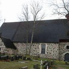
Raisio Church
1.3 km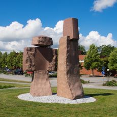
Church builders Killi and Nalli
1.2 km
Tuomala
1 km
Pappilanmäki
1.1 km
Nallinkatu
992 m
Tasalanhovi
941 m
Kyläklemelä
343 m
Iso-Kummala 1
1.1 km
Iso-Kummala 2
1.1 km
Lumparlanpuisto
1.2 km
Varppimäki
802 m
Optisen lennättimen muistomerkki
1 km
Tasalanhovi
948 m
Uho
1.1 km
Sadonkorjaajat II
1 km
Sankarihaudat
1.2 km
Ristinsuvannon muistolehto
1.3 km
Kiviristi Tien Pää
1.2 km
Varppimäki
791 m
Kalliorinne
667 m
Kosminen lintu
993 m
Lumparlanpuisto
1.2 km
Pappilanmäki
1.1 km
Nallinkatu
991 m
Iso-Kummala 1
1.1 km
Iso-Kummala 2
1.1 km
Sotiemme veteraanien muistolaatta
1.1 km
Itsenäinen Suomi
1.1 kmReviews
Visited this place? Tap the stars to rate it and share your experience / photos with the community! Try now! You can cancel it anytime.
Discover hidden gems everywhere you go!
From secret cafés to breathtaking viewpoints, skip the crowded tourist spots and find places that match your style. Our app makes it easy with voice search, smart filtering, route optimization, and insider tips from travelers worldwide. Download now for the complete mobile experience.

A unique approach to discovering new places❞
— Le Figaro
All the places worth exploring❞
— France Info
A tailor-made excursion in just a few clicks❞
— 20 Minutes