Erde
Location: Ayl
Creator: Joan Thimmel
Creator: Joan Thimmel
GPS coordinates: 49.63341,6.57310
Latest update: November 20, 2025 01:15
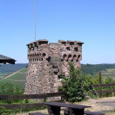
Bismarck Tower (Schoden)
522 m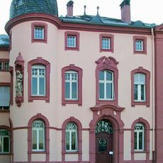
Schloss Ayl
1.4 km
Wayside cross
1.4 km
Schaftkreuz von 1621
1.5 km
Ayler Kupp
598 m
Scenic viewpoint
522 m
Heppenstein
1.1 km
Memorial
1.3 km
Wayside cross
860 m
Wayside cross
836 m
1939-1945
1.4 km
Wayside cross
1.5 km
Wayside cross
1.4 km
Wayside cross
1.4 km
Wasser
635 m
Kanu & SUP Station Schoden
237 m
Wayside cross
453 m
Wayside cross
1.4 km
Saar Knoten
3 m
Christianity, wayside cross
1.3 km
Wayside cross
1.4 km
Kreuzbildstock von 1828
746 m
Wayside shrine, Christianity
1.2 km
Pfeilerkreuz, Ende 19.Jh.
221 m
Wayside cross
1.4 km
II. Weltkrieg
647 m
Wayside cross
637 m
Memorial, war memorial
428 mReviews
Visited this place? Tap the stars to rate it and share your experience / photos with the community! Try now! You can cancel it anytime.
Discover hidden gems everywhere you go!
From secret cafés to breathtaking viewpoints, skip the crowded tourist spots and find places that match your style. Our app makes it easy with voice search, smart filtering, route optimization, and insider tips from travelers worldwide. Download now for the complete mobile experience.

A unique approach to discovering new places❞
— Le Figaro
All the places worth exploring❞
— France Info
A tailor-made excursion in just a few clicks❞
— 20 Minutes