Zahnradkugel
Location: Traunreut
Creator: Rolf Wassermann
Creator: Rolf Wassermann
GPS coordinates: 47.96417,12.60431
Latest update: November 16, 2025 16:19
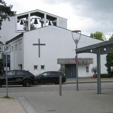
Pauluskirche
885 m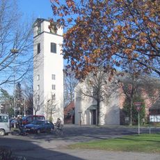
Zum Heiligsten Erlöser
877 m
Zugehörig Privatkapelle
1.5 km
Privatkapelle
2 km
Privatkapelle
2.2 km
Weilerkapelle
2.1 km
Cultural heritage D-1-8041-0091 in Traunreut
2.1 km
Kornspeicher Hofstätt 1 in Palling
2 km
Bildstock
2.2 km
Cultural heritage D-1-8041-0222 in Palling
2.1 km
Cultural heritage D-1-8041-0065 in Palling
728 m
Hofkapelle
1.5 km
Blockbau-Obergeschoss eines ehem. Kleinbauernhauses
2 km
Stadel mit Traufbundwerk
1.9 km
Kleinbauernhaus
1.4 km
St. Johannes Baptist
2.1 km
Bildstock
2.2 km
Theaterfabrik
626 m
Work of art, statue
909 m
Wayside shrine, Christianity
2.2 km
Mahnmahl
882 m
Pillbox, private road, subterranea, bunker
649 m
Heimatkreuz
357 m
Wayside cross
2.2 km
Catholic church building, wayside cross, Christianity
952 mReviews
Visited this place? Tap the stars to rate it and share your experience / photos with the community! Try now! You can cancel it anytime.
Discover hidden gems everywhere you go!
From secret cafés to breathtaking viewpoints, skip the crowded tourist spots and find places that match your style. Our app makes it easy with voice search, smart filtering, route optimization, and insider tips from travelers worldwide. Download now for the complete mobile experience.

A unique approach to discovering new places❞
— Le Figaro
All the places worth exploring❞
— France Info
A tailor-made excursion in just a few clicks❞
— 20 Minutes