Mt 6.10
Location: Unterbaldingen
Location: Bad Dürrheim
Inception: January 1, 2000
GPS coordinates: 47.97037,8.61150
Latest update: July 20, 2025 16:47
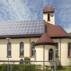
Evangelische Kirche
867 m
Kreuzweglinden (2 Linden)
1.4 km
Schreneneiche
1.4 km
Bergäcker (Mehlbeere, Stieleiche, Bergahorn)
1.3 km
Heubrunneneichen
1.1 km
Heubrunnenbäume (2 Roßkastanien, 8 Spitzahorne)
937 m
Flachterwegsbirne
884 m
Statue, Work of art
455 m
Wayside cross, Christianity
892 m
Wayside cross, Christianity
343 m
Catholic church building, wayside cross, Christianity
343 m
Commemorative plaque, Work of art, memorial
352 m
Catholic church building, wayside cross, Christianity
384 m
Wayside cross, Christianity
282 m
Wayside cross
462 m
Wayside cross, Christianity
859 m
Catholic church building, wayside cross, Christianity
274 m
Wayside cross, Christianity, Catholic church building
231 m
Catholic church building, wayside cross, Christianity
287 m
Kriegerdenkmal 1870-71
151 m
Wayside cross, Christianity
1.1 km
Kriegerdenkmal
1.1 km
Wayside cross, Christianity
111 m
Wayside cross, Christianity
1.2 km
Wayside cross
1.2 km
Sonderpreis - Linde
47 m
Kriegerdenkmal
25 m
MK 15,34 Schrei
15 mReviews
Visited this place? Tap the stars to rate it and share your experience / photos with the community! Try now! You can cancel it anytime.
Discover hidden gems everywhere you go!
From secret cafés to breathtaking viewpoints, skip the crowded tourist spots and find places that match your style. Our app makes it easy with voice search, smart filtering, route optimization, and insider tips from travelers worldwide. Download now for the complete mobile experience.

A unique approach to discovering new places❞
— Le Figaro
All the places worth exploring❞
— France Info
A tailor-made excursion in just a few clicks❞
— 20 Minutes