Friedensbaum
Location: Langenseifen
Location: Bad Schwalbach
GPS coordinates: 50.12186,8.00993
Latest update: November 22, 2025 22:45

Weißer Stein
1.7 km
Rheingauer Straße 28
2.3 km
Allhöh
892 m
Brunnen
2.2 km
Ehemalige Schule und Rathaus
2.3 km
Brunnen
2.3 km
Brunnensockel
2.2 km
Schmand-Kopf
2.3 km
Backhaus
2.1 km
Jagdhaus Dornbach
1.1 km
Ehemalige Schule
2.2 km
Obergeschoss-Traufwand
2.2 km
Lorcher Straße 24
181 m
Alte Schule
2.3 km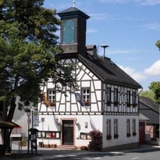
Rathaus
173 m
Rheingauer Straße 22
2.3 km
Scheune
154 m
Rheingauer Straße 16
2.4 km
Hainstraße 25
2.1 km
Alte Schule
226 m
Rheingauer Straße 18
2.4 km
Haus Holzweg 3
2.4 km
Brunnensockel
2.3 km
Gladbachklause
2.4 km
Haus Marktstraße 29Marktstraße
2.4 km
Dorfbrunnen
195 m
Scenic viewpoint
2 km
Scenic viewpoint
145 mReviews
Visited this place? Tap the stars to rate it and share your experience / photos with the community! Try now! You can cancel it anytime.
Discover hidden gems everywhere you go!
From secret cafés to breathtaking viewpoints, skip the crowded tourist spots and find places that match your style. Our app makes it easy with voice search, smart filtering, route optimization, and insider tips from travelers worldwide. Download now for the complete mobile experience.

A unique approach to discovering new places❞
— Le Figaro
All the places worth exploring❞
— France Info
A tailor-made excursion in just a few clicks❞
— 20 Minutes