Isla
Location: Mid Sussex
Creator: john grade
Creator: john grade
GPS coordinates: 51.06516,-0.09323
Latest update: November 17, 2025 00:22
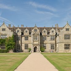
Wakehurst
376 m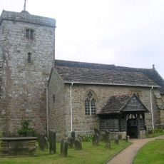
St Peter's Church, Ardingly
1.5 km
Jenkins Croft The Gardeners Arms Public House
804 m
Pearment's Farmhouse
1.4 km
Edmund's Farmhouse
1.5 km
Philpots Camp: a promontory fort and Mesolithic rock shelters 500m north west of Philpots Farm
1.6 km
Hickpots
1.3 km
The Croft
1.6 km
Bolney Farm
905 m
Horncombe
1.3 km
Woodward's Farmhouse
1.5 km
Jordan's Cottage
1.5 km
Lullings
1.3 km
Jordans
1.5 km
Stables To The North East Of Wakehurst Place
332 m
Brook Cottage
1.4 km
The Mount
754 m
Church Cottages
1.4 km
Ardingly Church Of England Primary School
1.5 km
Lunce Gate Cottage
1.3 km
The Labyrinth
309 m
The Glowing Canopies
445 m
Work of art, sculpture
277 m
Scenic viewpoint
165 m
Scenic viewpoint
346 m
Scenic viewpoint
332 m
Scenic viewpoint
479 m
Scenic viewpoint
673 mReviews
Visited this place? Tap the stars to rate it and share your experience / photos with the community! Try now! You can cancel it anytime.
Discover hidden gems everywhere you go!
From secret cafés to breathtaking viewpoints, skip the crowded tourist spots and find places that match your style. Our app makes it easy with voice search, smart filtering, route optimization, and insider tips from travelers worldwide. Download now for the complete mobile experience.

A unique approach to discovering new places❞
— Le Figaro
All the places worth exploring❞
— France Info
A tailor-made excursion in just a few clicks❞
— 20 Minutes