
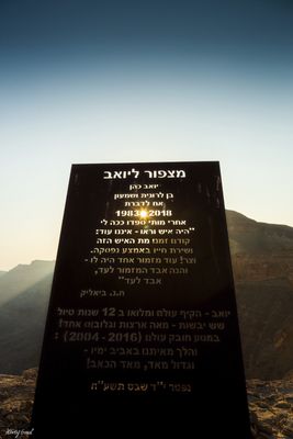
מצפור ליואב
Location: מועצה אזורית הערבה התיכונה
GPS coordinates: 30.93890,35.16809
Latest update: November 11, 2025 18:03

Ma'aleh Akrabim
5 km
מישור ימין
7.3 km
Rogem Safir
5.7 km
Mesad Safir
6 km
Hurvat Safir
5.7 km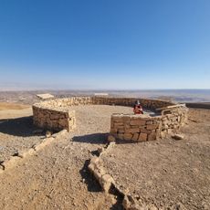
תצפית מעלה עקרבים
3.7 km
Small Mahtesh Viewpoint
487 m
Ma'ale Hatsera
7.6 km
מצפור מזר
7 km
Scenic viewpoint
5.8 km
Scropian Pass
4.8 km
Scenic viewpoint
6.9 km
ראש מעלה עלי
1.1 km
קניון נחל גוב
5.3 km
Ashmada Gate
5.1 km
Scenic viewpoint
3.7 km
Scenic viewpoint
4.2 km
Colored Sand
4.4 km
Scenic viewpoint
7 km
רוגם צפיר
5.7 km
מצד עקרבים
2 km
Operation Arava
3.6 km
מצד צפיר
6 km
דוד אייזנברג
7.6 km
חאן צפיר
5.7 km
שרידי מטוס קרב
3.1 km
עיקול ולאדי
5 km
מפל חצרה
7.2 kmReviews
Visited this place? Tap the stars to rate it and share your experience / photos with the community! Try now! You can cancel it anytime.
Discover hidden gems everywhere you go!
From secret cafés to breathtaking viewpoints, skip the crowded tourist spots and find places that match your style. Our app makes it easy with voice search, smart filtering, route optimization, and insider tips from travelers worldwide. Download now for the complete mobile experience.

A unique approach to discovering new places❞
— Le Figaro
All the places worth exploring❞
— France Info
A tailor-made excursion in just a few clicks❞
— 20 Minutes