
The Rock
Location: Stroud
Website: https://www.geograph.org.uk/photo/7835922
Website: https://geograph.org.uk/photo/7835922
GPS coordinates: 51.74646,-2.27543
Latest update: November 21, 2025 07:05


Assembly Room To South Of Crown And Anchor
524 m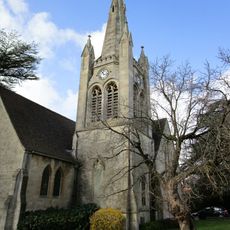
Wycliffe College Chapel Spire
431 m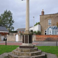
Stonehouse War Memorial
621 m
Ryeford Bridge
768 m
Queen Anne Cottage
426 m
Bede Cottage
674 m
No 10 (Hill View House) And No 12
718 m
Berryfields House And North Berryfields
793 m
Tankard House
717 m
Haywardsend
451 m
Apsley House
501 m
Coach House To North Of Crown And Anchor
540 m
School House
424 m
Barclays Bank
593 m
Ryeford House
715 m
Holmleigh
640 m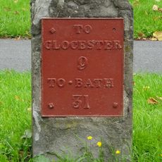
Milestone
570 m
Hill View House
683 m
Haywardsend Mews
431 m
35, Regent Street
590 m
Former Coal Pens Near Canal Cottages
754 m
Tudor House
549 m
Nos 58, 60 (Orchard House) And 62
602 m
80, High Street
637 m
The Mount
698 m
Railway Boundary Marker
444 m
Ivy Grove
448 m
Bench, scenic viewpoint
24 mReviews
Visited this place? Tap the stars to rate it and share your experience / photos with the community! Try now! You can cancel it anytime.
Discover hidden gems everywhere you go!
From secret cafés to breathtaking viewpoints, skip the crowded tourist spots and find places that match your style. Our app makes it easy with voice search, smart filtering, route optimization, and insider tips from travelers worldwide. Download now for the complete mobile experience.

A unique approach to discovering new places❞
— Le Figaro
All the places worth exploring❞
— France Info
A tailor-made excursion in just a few clicks❞
— 20 Minutes