Location: ស្រុកស្វាយលើ
Website: https://images.mapillary.com/_GoNFPxRzFb41X8PGRhF6g/thumb-2048.jpg
Website: https://images.mapillary.com/_GoNFPxRzFb41X8PGRhF6g/thumb-2048.jpg
GPS coordinates: 13.47915,104.22905
Latest update: October 25, 2025 11:06
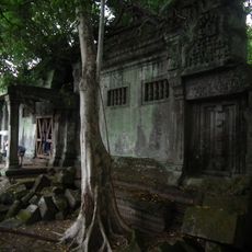
Beng Mealea
1.1 km
Kong Phlouk Temple
2.7 km
Toab-Chey-Thom-Tempel
13.5 km
Ruins
476 m
Змеи-наги
476 m
Sam Yot Temple
5.2 km
Work of art, sculpture
776 m
Work of art, sculpture
834 m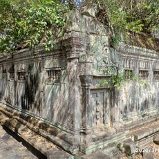
Prasat Beng Mealea
396 m
Ruins
1.1 km
Wayside shrine
1.6 km
Chrey Temple
2 km
Ruins
2.7 km
Angkorian Sandstone Quarry
432 m
Beng Mealea
365 m
Ruins
680 m
Scenic viewpoint
7.4 km
Poeng Eisei
10.2 km
ពើងគំនូរ
10.9 km
Sras Dam Rey (Elephant Statue)
11.3 km
Brahma
11.6 km
កំណាយឡបុរាណ
12 km
Scenic viewpoint
12 km
មហេន្ទ្របវ៌ត
12.5 km
Waterfall
3.3 km
Rocks with prehistoric paintings
13.5 km
Toab-Chey-Tauch-Tempel
13.8 km
Scenic viewpoint
14.8 kmReviews
Visited this place? Tap the stars to rate it and share your experience / photos with the community! Try now! You can cancel it anytime.
Discover hidden gems everywhere you go!
From secret cafés to breathtaking viewpoints, skip the crowded tourist spots and find places that match your style. Our app makes it easy with voice search, smart filtering, route optimization, and insider tips from travelers worldwide. Download now for the complete mobile experience.

A unique approach to discovering new places❞
— Le Figaro
All the places worth exploring❞
— France Info
A tailor-made excursion in just a few clicks❞
— 20 Minutes