
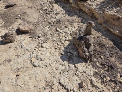
מאובני אומניטים
Location: מועצה אזורית הערבה התיכונה
GPS coordinates: 30.78752,35.02982
Latest update: October 25, 2025 11:12
Maklef lookout
8.4 km
Scenic viewpoint
5.2 km
עיקול פרסה בנחל צין
7.7 km
Scenic viewpoint
6.9 km
Ruins
7.3 km
Waterfall
5 km
Bulbusim Field
5 km
שדה בולבוסים
5.1 km
מפל חגור
3.3 km
Waterfall
5.3 km
מפל טרף
5.4 km
Scenic viewpoint
5.8 km
Scenic viewpoint
6.4 km
Scenic viewpoint
2.5 km
יאיר טויטו
7.2 km
Scenic viewpoint
7.3 km
Scenic viewpoint
4 km
העין של הר רכב
7.4 km
ציורי סלע
7.5 km
Waterfall
996 m
ירון
7.8 km
רונן לב, ירון וינוטה
7.9 km
Scenic viewpoint
8 km
Waterfall
8.4 km
מאובנים
221 m
שיניות
8.9 km
"סולם יעקב"
9.2 km
אריאל יהודאי
9.2 kmReviews
Visited this place? Tap the stars to rate it and share your experience / photos with the community! Try now! You can cancel it anytime.
Discover hidden gems everywhere you go!
From secret cafés to breathtaking viewpoints, skip the crowded tourist spots and find places that match your style. Our app makes it easy with voice search, smart filtering, route optimization, and insider tips from travelers worldwide. Download now for the complete mobile experience.

A unique approach to discovering new places❞
— Le Figaro
All the places worth exploring❞
— France Info
A tailor-made excursion in just a few clicks❞
— 20 Minutes