
昭和9年 室戸台風 最高水位OP+5.10m ここの歩道高OP0.90m 平均満潮位OP2.10m
Location: 尼崎市
Inscription: 昭和9年 室戸台風 最高水位OP+5.10m
GPS coordinates: 34.71771,135.39645
Latest update: November 6, 2025 18:56
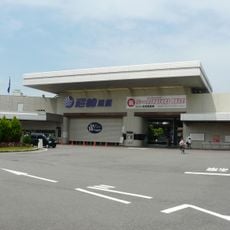
Boat Race Amagasaki
302 m
大庄地区
860 m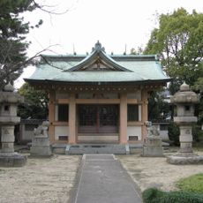
Kotoura-jinja
425 m
阪神71形 74号
640 m
子安地蔵尊
738 m
百姓中
455 m
Statue, Work of art
458 m
Statue, Work of art
458 m
Work of art, statue
459 m
Work of art, statue
460 m
阪神71形 71号
472 m
龍田地蔵尊
483 m
Wayside shrine
565 m
Wayside shrine
219 m
大庄村道路元標
655 m
尼崎市工業用水道南配水場跡
676 m
Wayside shrine
442 m
Commemorative plaque, memorial
760 m
Wayside shrine
776 m
Wayside shrine
792 m
Wayside shrine
792 m
Wayside shrine
814 m
わんぱく池
817 m
昭和25年 ジェーン台風 最高水位OP+4.30m ここの歩道高OP(+)0.90m 平均満潮位OP(+)2.10m
0 m
Wayside shrine
871 m
Wayside shrine
974 m
Wayside shrine
978 m
Wayside shrine
995 mReviews
Visited this place? Tap the stars to rate it and share your experience / photos with the community! Try now! You can cancel it anytime.
Discover hidden gems everywhere you go!
From secret cafés to breathtaking viewpoints, skip the crowded tourist spots and find places that match your style. Our app makes it easy with voice search, smart filtering, route optimization, and insider tips from travelers worldwide. Download now for the complete mobile experience.

A unique approach to discovering new places❞
— Le Figaro
All the places worth exploring❞
— France Info
A tailor-made excursion in just a few clicks❞
— 20 Minutes