Wayside shrine
Location: Kirchberg bei Mattighofen
GPS coordinates: 48.03810,13.10139
Latest update: November 3, 2025 15:29

Pfarrkirche Auerbach
3 km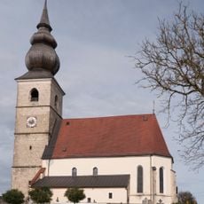
Pfarrkirche hl. Kunigunde, Kirchberg bei Mattighofen
129 m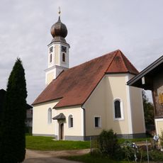
Kath. Filialkirche hl. Martin und ehem. Friedhof
1.7 km
Pfarrhof
218 m
Panorama von Kirchberg bei Mattighofen und Alpenvorland
324 m
Wayside shrine
2.2 km
Wayside shrine
303 m
Memorial, commemorative plaque
326 m
Heiliger Martin
620 m
Holzkreuz mit Dach, Rückwand und kleiner Christusfigur
906 m
Christianity, Catholic church building, wayside cross
1.2 km
Castell-Höhe
1.3 km
Memorial
1.4 km
Catholic church building, wayside cross, Christianity
277 m
Wayside cross, Christianity, Catholic church building
1.8 km
Catholic church building, wayside cross, Christianity
1.9 km
Wayside shrine
2.1 km
Holzkreuz mit Dach und kleiner Christusfigur
310 m
Christianity, Catholic church building, wayside cross
2.3 km
Catholic church building, wayside cross, Christianity
2.5 km
Wayside shrine
2.6 km
Catholic church building, wayside cross, Christianity
2.7 km
Wolfgang Huber
2.8 km
Wayside cross, Christianity, Catholic church building
2.8 km
Wayside shrine
2.8 km
Dorfplatzerneuerung
2.9 km
Catholic church building, wayside cross, Christianity
3 km
Kriegerdenkmal
146 mReviews
Visited this place? Tap the stars to rate it and share your experience / photos with the community! Try now! You can cancel it anytime.
Discover hidden gems everywhere you go!
From secret cafés to breathtaking viewpoints, skip the crowded tourist spots and find places that match your style. Our app makes it easy with voice search, smart filtering, route optimization, and insider tips from travelers worldwide. Download now for the complete mobile experience.

A unique approach to discovering new places❞
— Le Figaro
All the places worth exploring❞
— France Info
A tailor-made excursion in just a few clicks❞
— 20 Minutes