Stadler Kapelle
Location: St. Peter am Wimberg
GPS coordinates: 48.54337,14.09103
Latest update: November 14, 2025 02:10
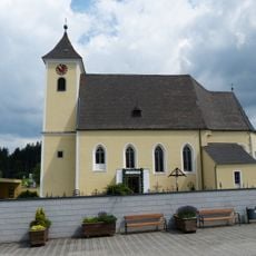
Sankt Stefan am Walde - Parish church
2.8 km
Burgstall Haglau
1.9 km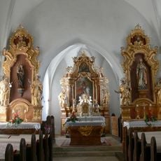
St.Georg in Hollerberg
2.3 km
Ortskapelle
2.5 km
Auberg - Unterkagererhof
2.2 km
Unterriedl
1 km
Kapelle
2.8 km
Wayside shrine
1.6 km
Hütte des Einsiedlers
2.8 km
Teufelsstein
2.2 km
Wendenstein
2.8 km
Scenic viewpoint
3 km
Drudenstein
2.8 km
Eisernes Kreuz
2.6 km
Stefanstritt
2.8 km
Wiesmayrkapelle
2.4 km
Wayside cross
2.1 km
Teufelssitz
2.6 km
Unterkagererkapelle
2.2 km
Lüftnerkreuz
2.1 km
Wayside cross
3 km
Wayside shrine
2.1 km
Schoachn Kapelle
918 m
Wayside shrine
2.6 km
Wayside shrine
2.6 km
Wayside shrine
2.6 km
Wayside cross
3.1 km
Wayside cross
2.7 kmReviews
Visited this place? Tap the stars to rate it and share your experience / photos with the community! Try now! You can cancel it anytime.
Discover hidden gems everywhere you go!
From secret cafés to breathtaking viewpoints, skip the crowded tourist spots and find places that match your style. Our app makes it easy with voice search, smart filtering, route optimization, and insider tips from travelers worldwide. Download now for the complete mobile experience.

A unique approach to discovering new places❞
— Le Figaro
All the places worth exploring❞
— France Info
A tailor-made excursion in just a few clicks❞
— 20 Minutes