II
Location: Gloggnitz
Inscription: Jesus nimmt das schwere Kreuz auf seine Schultern
GPS coordinates: 47.66711,15.90857
Latest update: November 13, 2025 15:42
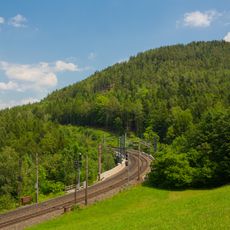
Abfaltersbach viaduct
540 m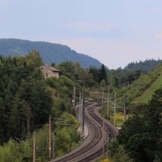
Südbahnstrecke Semmering-Bahn (Gloggnitz-Mürzzuschlag)
802 m
Südbahnstrecke Semmering-Bahn (Gloggnitz-Mürzzuschlag)
432 m
Tree, wayside shrine
1.1 km
III
20 m
Scenic viewpoint
83 m
Scenic viewpoint
752 m
Bildstock
775 m
Gailhoferkapelle
353 m
Praschkapelle
841 m
Wayside shrine
874 m
Wayside cross
1 km
Wayside cross
665 m
Hainischgruft
1 km
Scenic viewpoint, bench
633 m
I
23 m
Bench, scenic viewpoint
1.2 km
IV
41 m
V
56 m
VI
59 m
VII
66 m
VIII
85 m
IX
97 m
X
117 m
XI
131 m
XII
154 m
XIII
174 m
Wayside shrine
797 mReviews
Visited this place? Tap the stars to rate it and share your experience / photos with the community! Try now! You can cancel it anytime.
Discover hidden gems everywhere you go!
From secret cafés to breathtaking viewpoints, skip the crowded tourist spots and find places that match your style. Our app makes it easy with voice search, smart filtering, route optimization, and insider tips from travelers worldwide. Download now for the complete mobile experience.

A unique approach to discovering new places❞
— Le Figaro
All the places worth exploring❞
— France Info
A tailor-made excursion in just a few clicks❞
— 20 Minutes