Railway carriage
Location: Elsenborn
Location: Bütgenbach
GPS coordinates: 50.52045,6.20606
Latest update: November 3, 2025 18:32
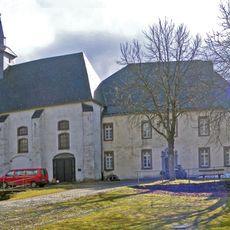
Reichenstein Monastery
2.1 km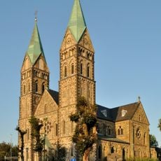
St. Lambertus
1 km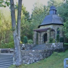
Norbertuskapelle
1.7 km
Klüserbachtal und Schwarzbachtal
875 m
Breitenbachtal
1.7 km
Antoniuskapelle
618 m
Kalterherberg West
798 m
Oberlauf der Rur
2 km
LSG-Stellerholz
1.4 km
LSG-Roemerbachtal/Kluesenborn
2 km
Ruitzhof
805 m
LSG-Langenbruch
986 m
Kalterherberg Engelgasse
2 km
LSG-Breitenbachtal Nord
422 m
Eifelblick Am Röster
1.1 km
Erlebnisstation 1 Belgischer Zöllner in Kalterherberg
909 m
Wayside cross
1.4 km
Wayside cross
1.4 km
Wayside cross
1 km
Wayside cross
1 km
Wayside cross
1.8 km
Wayside shrine
1.8 km
Wayside cross
1.9 km
Theißbaum
1.9 km
Mariengrotte
2 km
Prior Stephan Horrichem
1 km
Wayside cross
1 km
Kriegerdenkmal
1 kmReviews
Visited this place? Tap the stars to rate it and share your experience / photos with the community! Try now! You can cancel it anytime.
Discover hidden gems everywhere you go!
From secret cafés to breathtaking viewpoints, skip the crowded tourist spots and find places that match your style. Our app makes it easy with voice search, smart filtering, route optimization, and insider tips from travelers worldwide. Download now for the complete mobile experience.

A unique approach to discovering new places❞
— Le Figaro
All the places worth exploring❞
— France Info
A tailor-made excursion in just a few clicks❞
— 20 Minutes