High water mark
Location: Bouguenais
Inscription: CRUE 1918
GPS coordinates: 47.18036,-1.62177
Latest update: November 13, 2025 09:52
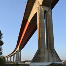
Pont de Cheviré
1.5 km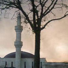
Osmanli Mosque
2.2 km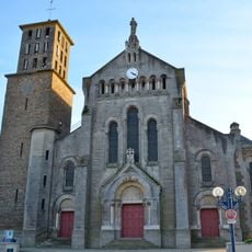
Église Saint-Pierre de Bouguenais
188 m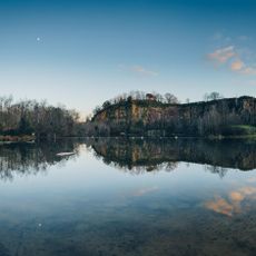
Roche Ballue
2.4 km
Terrain de moto-cross de Tougas
2.4 km
Piano'cktail
1.4 km
The Settlers
1.5 km
Fountain
163 m
Chaire à prêcher de l'église Saint-Pierre de Bouguenais
194 m
Centre Baptiste Marcet
2.5 km
Château de la Guerinière
2.3 km
Scenic viewpoint
2.5 km
Scenic viewpoint
2 km
Scenic viewpoint
2.3 km
Sémaphore de Roche-Maurice
1.6 km
Vue sur le Pont
74 m
Pedestrian zone, scenic viewpoint
2.3 km
Toussaint Louverture
1.7 km
Scenic viewpoint
2.4 km
Wayside cross
1.4 km
The Settlers
1.9 km
Wayside cross
403 m
Wayside cross
2.1 km
Wayside cross
565 m
Wayside shrine
1.8 km
Wayside cross
2.1 km
Wayside cross
1.4 km
Avion de manoeuvre
2.2 kmReviews
Visited this place? Tap the stars to rate it and share your experience / photos with the community! Try now! You can cancel it anytime.
Discover hidden gems everywhere you go!
From secret cafés to breathtaking viewpoints, skip the crowded tourist spots and find places that match your style. Our app makes it easy with voice search, smart filtering, route optimization, and insider tips from travelers worldwide. Download now for the complete mobile experience.

A unique approach to discovering new places❞
— Le Figaro
All the places worth exploring❞
— France Info
A tailor-made excursion in just a few clicks❞
— 20 Minutes