High water mark
Location: Sainte-Gemmes-sur-Loire
GPS coordinates: 47.41976,-0.55960
Latest update: November 6, 2025 18:56

Église Saint-Aubin des Ponts-de-Cé
2.7 km
Dumnacus Bridge
2.7 km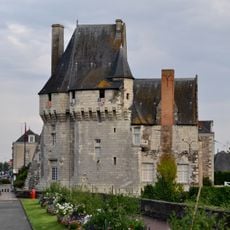
Château des Ponts-de-Cé
2.6 km
Manoir de Belligan
3.1 km
Vestiges archéologiques gallo-romains de Sainte-Gemmes-sur-Loire
2.8 km
Église Saint-Jean-Baptiste de Saint-Jean-de-la-Croix
2.8 km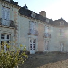
Château d'Orgemont
3 km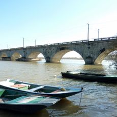
Bouchemaine Railway Bridge
3.4 km
Scenic viewpoint
2.6 km
Scenic viewpoint
2.1 km
Scenic viewpoint
2.5 km
Scenic viewpoint
1.6 km
La Roche de Mûrs
2.2 km
Wayside cross
2.7 km
Wayside cross
625 m
Wayside cross, Christianity, Catholic church building
1.8 km
Théâtre des Dames
2.5 km
Statue, Work of art
2.7 km
Wayside cross
2.7 km
Monument Républicain
2.2 km
Sculpture, Work of art
2.6 km
High water mark
2.8 km
Wayside cross
493 m
Memorial, war memorial
444 m
Théâtre du Césame
279 m
Wayside cross
3.1 km
Monument
3.1 km
Scenic viewpoint
83 mReviews
Visited this place? Tap the stars to rate it and share your experience / photos with the community! Try now! You can cancel it anytime.
Discover hidden gems everywhere you go!
From secret cafés to breathtaking viewpoints, skip the crowded tourist spots and find places that match your style. Our app makes it easy with voice search, smart filtering, route optimization, and insider tips from travelers worldwide. Download now for the complete mobile experience.

A unique approach to discovering new places❞
— Le Figaro
All the places worth exploring❞
— France Info
A tailor-made excursion in just a few clicks❞
— 20 Minutes